Scientists discover “8th continent” Zealandia
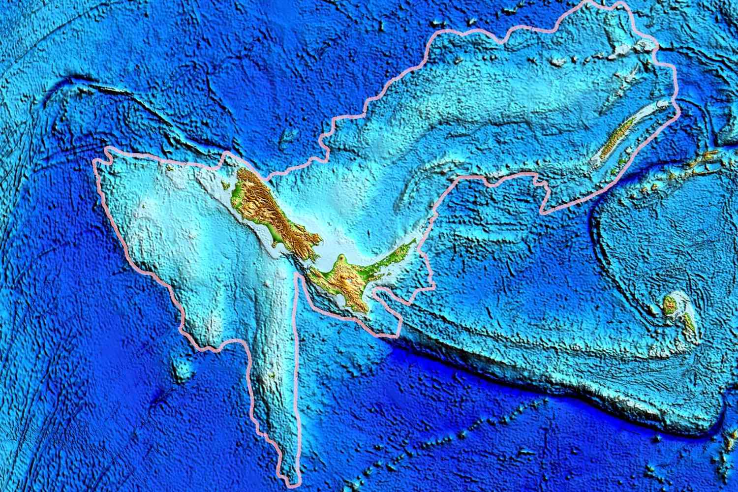
Scientists recently discovered a new continent that had been missing from our knowledge for 375 years. This continent, called Zealandia, is mostly underwater but consists of a group of islands, similar to New Zealand. Zealandia was originally part of the ancient supercontinent Gondwana, which existed about 1 billion to 542 million years ago.
Geoscientists found Zealandia after centuries of it going unnoticed and created a more detailed map of it. They gathered data by studying rock samples from the ocean floor, and their findings were published in the journal Tectonics, which focuses on Earth’s structure and evolution.
According to a BBC report, Zealandia is a vast continent, about six times the size of Madagascar, covering 1.89 million square miles or 4.9 million square kilometres. It’s the eighth continent discovered, and it’s the smallest, thinnest, and youngest one. — alphabetagama20 (@alphabetagama20)
Andy Tulloch from the New Zealand Crown Research Institute GNS Science noted, “This is an example of how something very obvious can take a while to uncover.”
Zealandia has been a challenging subject for scientists to study. Researchers collected rock and sediment samples from the ocean floor, primarily from drilling sites and some from the shores of nearby islands.
Scientists were surprised to find tectonic plate activity in West Antarctica that could have influenced other parts of the Earth. This activity is near the Campbell Plateau, an underwater plateau off New Zealand’s west coast.
Interestingly, no magnetic anomalies were found in this area, which contradicts some theories about how the Earth’s crust moves along the Campbell Fault.
The updated map of Zealandia not only reveals the location of volcanic activity but also provides information about the continent’s structure and other important features.
Zealandia was once part of the Gondwana supercontinent, which formed about 550 million years ago. Gondwana was a massive landmass that included most of the land in the southern hemisphere.
According to BBC, in another study, a different research team, which included several of the same geologists, focused on North Zealandia, specifically the Fairway Ridge region in the South Pacific off Australia’s coast, Zealandia’s northernmost tip.
They analyzed ancient rocks, untouched by dry land for 25 million years, comprising a mix of volcanic and sedimentary formations. By scrutinizing their chemistry and radioactive isotopes, they determined the rocks’ ages, revealing pebbles from the Early Cretaceous, sandstone from the Late Cretaceous, and younger basalts from the Eocene, transforming Zealandia from an obscure landmass into a region characterized by distinct geological bands that align with West Antarctica.
The subsequent investigation examined magnetic anomalies in the ocean floor surrounding Zealandia, shedding light on its ancient stretching and directional shifts that resulted in its transformation into an ultra-thin continent that eventually submerged, offering tantalizing glimpses into Zealandia’s geological history, a process likely to unfold gradually given the vast expanse of this enigmatic submerged landmass.
Also Read: How The Giraffe Got Its Long Neck (Pictures)
While Zealandia meets the first three criteria, the research notes that the definition of “continent size” is ambiguous. It poses the question of whether Zealandia, with its approximately five million square kilometers, falls into the category of a continent or remains a large island.
There is a long debate over the precise size required for continent status, as there is no geological basis for setting a specific cutoff. It suggests that one million square kilometers is one possible cutoff, but this figure is somewhat arbitrary.
